by admin
Share
by admin
Share

Trigg Minerals has completed high-resolution satellite imagery analysis over the entire Achilles Antimony project landholding. The process undertaken has led to the identification of 30 new target areas, each requiring further investigation through field exploration.
The Achilles project is host to the JORC Compliant Wild Cattle Creek Antimony deposit (15,600t contained Antimony at 2.56%), which features some of Australia’s thickest and highest-grade Antimony intersections.
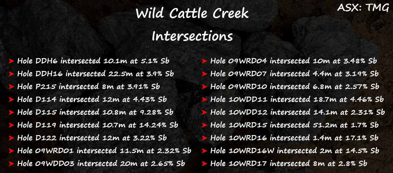
The Achilles project boasts numerous historical high-grade antimony mines across a substantial 6km strike that have never been subjected to modern and systematic exploration methods.
Ultra high-grade intersections have been identified from sporadic historical drilling with grades up to 11.8% Sb (Hole DDH36 – Jezebel Prospect). These intersections are beyond the boundaries of the Wild Cattle Creek deposit and are not included in the current mineral resource estimate. These results underscore the potential for further high-grade resource expansion.
Exploration efforts are focusing on completing data compilation and geophysical surveys to prioritise exploration targets based on geological potential and exploration viability.
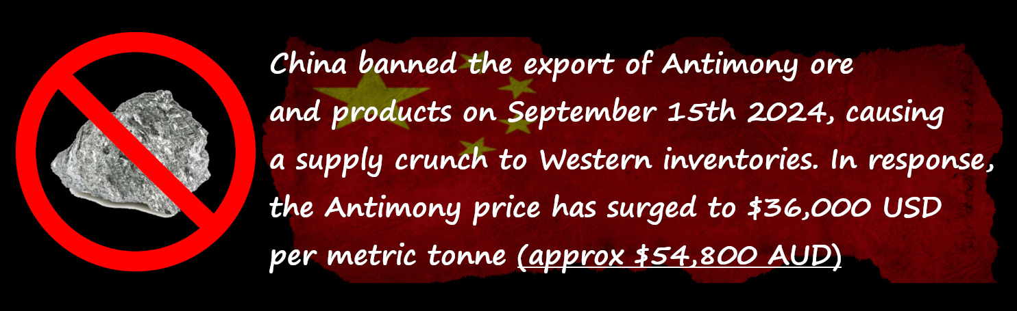
The company has stated that it has received unsolicited approaches regarding potential M&A and off-take activity. These developments come as Western governments and suppliers desperately seek to secure alternative sources for Antimony after China implemented its export ban on September 15, 2024.
REMOTE SENSING STUDY
Trigg Minerals secured the services of remote sensing and image processing specialists Dirt Exploration (Dr Neil Pendock).
Dr. Pendock boasts over 30 years of experience as an applied mathematician revolutionising the processing and interpretation of remotely sensed data for geophysics and mining. He has developed cutting-edge software for major systems like Landsat TM and the De Beers hyperspectral airborne scanner, enhancing data analysis for exploration.
Dr Pendock acquired, processed and analysed a suite of satellite imagery over the Achilles Antimony project land holding:
- Sentinel visible/near-infrared [VNIR]
- Shortwave infrared [SWIR]
- PULSAR synthetic aperture radar [SAR]
The 30 new exploration targets were generated by training a multivariate statistical classifier on 12 drill holes from the Wild Cattle Creek Deposit contained within the project. The classifier is a digital fingerprint of the antimony response in the region of interest.
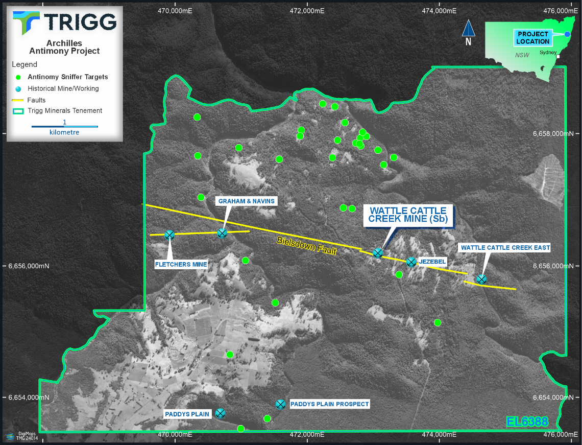
Figure 1: Mercury and Methane gas targets across the Achilles Project and its known prospects.
Numerous gas anomalies demonstrate a WNW-trending pattern, which could suggest a line of potentially mineralisation-rich structures running close to parallel with the Bielsdown Fault. This trend is especially clear in the northern part of the Achilles Project.
The study has pinpointed several promising areas for antimony mineralisation, which are now being ranked and prioritised based on Sentinel and radar data, along with existing geological mapping and known rock geochemistry. Ground reconnaissance of the newly identified 30 targets will be conducted as access to these areas becomes available.
Mercury and methane are strongly associated with antimony in hydrothermal systems of the New England Orogen. Methane is crucial in mineralisation processes, while mercury—unique among metals for its ability to vaporise at relatively low temperatures—occurs in its native form or as cinnabar within the Wild Cattle Creek deposit. The VNIR/SWIR spectral unmixing has identified an end member interpreted as stibnite and quartz, with antimony occurring within quartz veins. The stibnite response also correlates with mercury estimates, suggesting that mercury gas may serve as a useful indicator for concealed targets.
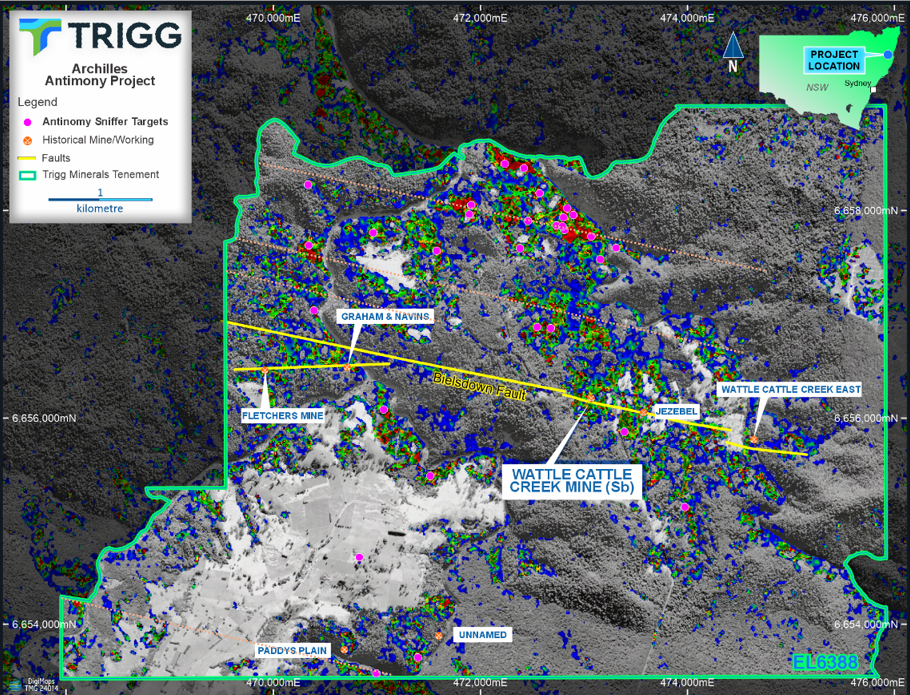
Figure 2: Mercury and Methane target layer with selected gas targets, historical prospects and key structures known to host antimony mineralisation. Interpreting the target layer Heat gradient – red is high mercury vapour/Methane gas = Stibnite; blue is background.
The remote sensing study highlights the potential for discovering antimony-rich mineralised structures, similar to the Bielsdown Fault, running in a parallel West-North-West direction.
Disclaimer: Bullseye Analytics (the company) or associated entities own 150,000,000 TMGOD options as of the publication date of this article.